Viewing the Data Displayed on the Map
The Advanced GIS
tool is used to view the data referring to definite territorial
units – provinces and/or cities/villages when zoomed in to this
level. In order to access the data for a specific territorial
unit, point the mouse cursor on the ![]() button
(Figure: Viewing the Data Displayed on the Map). The information
that is displayed in the information window includes but is not
limited to # of people in need of shelter, # of houses totally
destroyed, estimate # of households, etc. If you have plotted
any chart category on the map, the chart
category details appear in the information window as well.
button
(Figure: Viewing the Data Displayed on the Map). The information
that is displayed in the information window includes but is not
limited to # of people in need of shelter, # of houses totally
destroyed, estimate # of households, etc. If you have plotted
any chart category on the map, the chart
category details appear in the information window as well.
Alternatively,
you can choose to view the project information referring not to
a specific territorial unit, but to the whole country. For this
purpose, you will have to point the mouse cursor on the  button
in the Nation Wide section.
button
in the Nation Wide section.
Note: Clicking the View Projects link at the bottom of the information window will take you to the Details section of the application. For more information about the actions that can be taken in this section, see DETAILS SECTION.
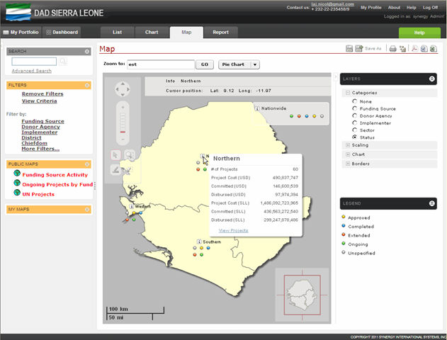 |
Figure: Viewing the Data Displayed on the Map |